


What Is the ENCPA (East Nassau Community Planning Area)?
The ENCPA is a state-approved sector plan adopted by Nassau County in 2011 and embedded in the County’s Comprehensive Plan. It covers roughly 24,000 acres in eastern Nassau County, generally north of SR 200/A1A, east of I-95, and extending toward US-17 and Chester Road.

This is not ordinary zoning. A sector plan is a long-range, master-planned growth framework designed to allow very large-scale development to occur in phases, with infrastructure, land use, and transportation planned together rather than parcel by parcel.
Nothing is built automatically under ENCPA. Every development phase must still go through Detailed Specific Area Plans (DSAPs), public hearings, and county approval.
Planning Timeline: How Long Does ENCPA Cover?
ENCPA was structured under Nassau County’s 2030 Comprehensive Plan, but in practical terms it is a multi-decade buildout plan, not a short-term project.
The plan establishes:
Early benchmark periods (2010–2015) A maximum cumulative buildout by 2030 Continued phased development afterward, subject to DSAP approvals and infrastructure capacity
Sector plans like this are commonly expected to unfold over 30–50 years, depending on market conditions, infrastructure timing, and political decisions. ENCPA is no exception.
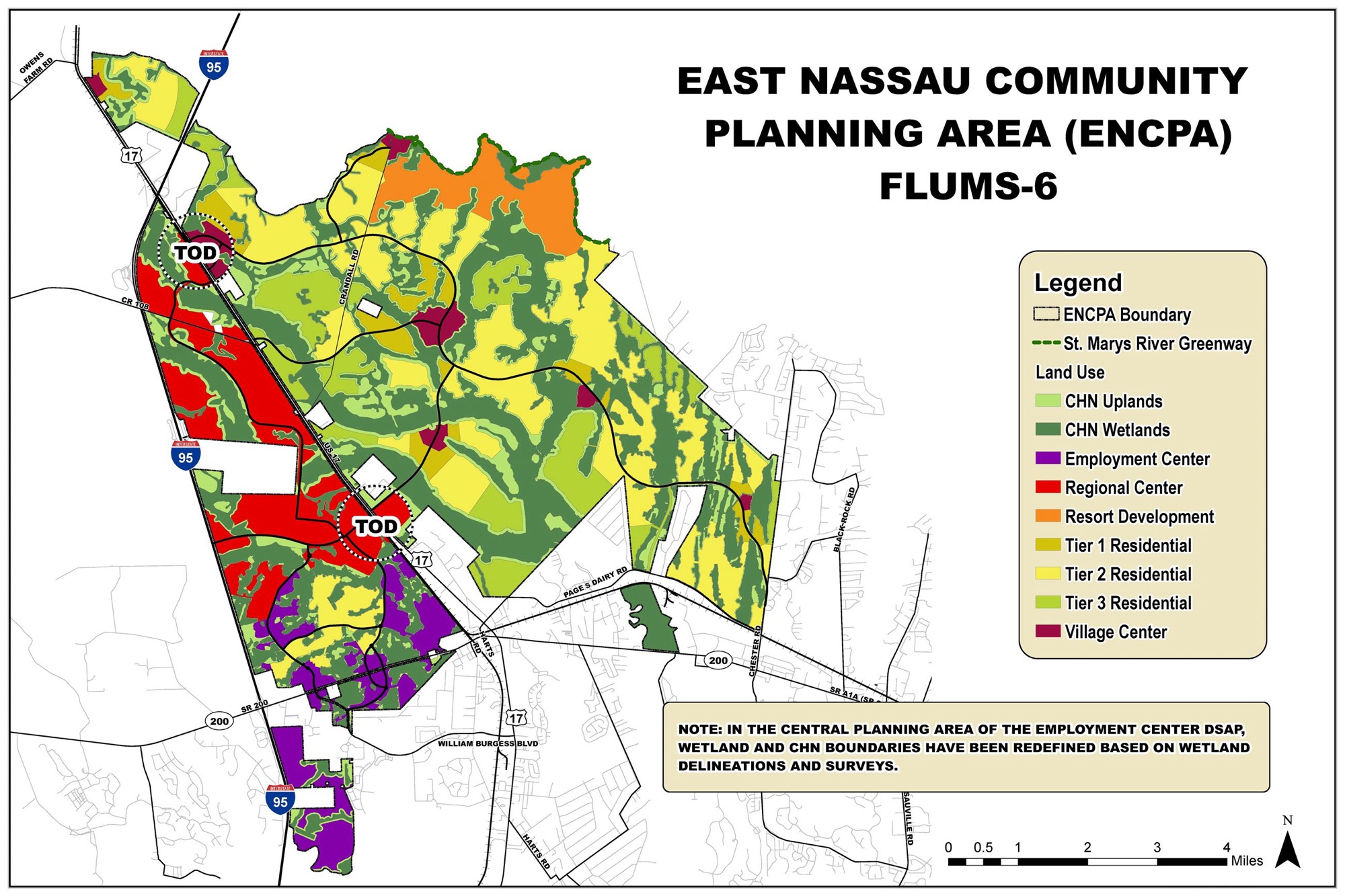
Abbreviations on the ENCPA Master Land Use Map (Explained Clearly)
These abbreviations appear on the official ENCPA Master Land Use Plan map. They describe planning concepts, not guaranteed entitlements.
ENCPA — East Nassau Community Planning Area
The overall sector-planned area governed by special policies in the Comprehensive Plan.
TOD — Transit Oriented Development
Higher-density, mixed-use development planned around future or potential transit corridors. Emphasis is on walkability, internal circulation, reduced car dependence, and clustering of housing, jobs, and services. TOD areas allow some of the highest residential and non-residential intensity in the plan.
RC — Regional Center
The most intense development nodes. These are designed to support large-scale employment, office, commercial activity, and supporting residential uses that serve the broader region, not just nearby neighborhoods.
EC — Employment Center
Areas focused on job creation: office parks, industrial uses, logistics, research, and related commercial services. Residential uses are limited or secondary.
VC — Village Center
Smaller, community-scale mixed-use hubs intended to serve surrounding residential areas. These typically include local retail, schools, civic uses, and medium-density housing.
MU — Mixed Use
Areas where residential, commercial, office, and civic uses are intentionally blended. This can occur vertically (same building) or horizontally (same district).
IC — Industrial / Commerce (or Industrial Center)
Areas reserved for heavier employment uses such as warehousing, distribution, manufacturing, and large-format commercial. Generally not residential-friendly.
R — Residential
Primarily housing areas. Actual density varies and is determined later through DSAP approvals.
OS — Open Space
Preserved lands including wetlands, conservation areas, buffers, parks, and green corridors. These are not “land banks” for future development.
ROW — Right of Way
Existing or planned transportation corridors, including major roads and future connectors.
SR / US Labels (e.g., SR 200, US-17)
State and federal highway references shown for orientation and transportation planning.
DSAP — Detailed Specific Area Plan
Not always printed on the map, but critical. No development proceeds in ENCPA without a DSAP, which sets exact density, uses, road improvements, school impacts, and mitigation requirements.
Potential Population Impact at Full Buildout
This is the part that matters most to residents.
The ENCPA allows, at full buildout:
Up to approximately 24,000 dwelling units Roughly 11 million square feet of non-residential development
Using conservative planning assumptions:
Average household size: 2.4–2.6 people per unit
That places the potential residential population between 55,000 and 62,000 people when fully built out.
That figure does not include:
Daily in-commuters for employment centers Visitors, service traffic, or regional commercial draw Secondary impacts on surrounding areas outside ENCPA
In practical terms, ENCPA represents the equivalent of adding a mid-sized city to eastern Nassau County over time. Roads, schools, utilities, emergency services, and tax structures are all expected to scale accordingly — at least on paper.
Bottom Line
ENCPA is not speculative. It is a legally adopted, long-range growth framework with defined maximums, phased approvals, and significant population implications. The map is not zoning, but it is not meaningless either. It sets the outer boundaries for what Nassau County has already agreed can happen — provided future commissions approve each step.
Important clarification on units (per Commissioner Huppman)
After earlier discussion, Commissioner Huppman reached out with an important clarification that improves accuracy and context.
The commonly cited 24,000 residential units figure refers to the entire ENCPA program across all phases and planning areas, not just Wildlight.
More accurate breakdown:
Wildlight: approximately 12,000 residential units Total ENCPA (all phases combined): approximately 24,000 residential units Approximately 12,000 acres are projected conservation lands, meaning roughly half the ENCPA remains undeveloped
Some online sources collapse these figures and make it sound like 24,000 units are all being built east of I-95 at once. That is not correct.
Infrastructure and amenities that were originally approved (often left out)
ENCPA and Wildlight were approved with significant infrastructure and land-use planning, including:
A new east–west transportation corridor connecting Chester Road to I-95 Multiple town centers (not single-use subdivisions) Six planned schools Employment and commercial districts designed to reduce outbound commuting Large, contiguous conservation areas An approximately 8-mile “green ribbon” conservation trail with public access along the St. Mary’s River A future riverfront resort on the St. Mary’s River bluff, often described as comparable in scale to the Omni and frequently referenced as a Four Seasons–type concept
This was approved as a master-planned community, not piecemeal sprawl.
Population impact (using corrected numbers)
Using standard planning assumptions of 2.4–2.6 people per household:
Wildlight alone (12,000 units): roughly 29,000–31,000 residents Full ENCPA buildout (24,000 units total): roughly 55,000–62,000 residents
That is effectively adding a small to mid-sized city to eastern Nassau County over time.
Whether ENCPA ultimately feels like smart growth or overreach depends entirely on how DSAPs are approved, how infrastructure is funded, and whether population impacts are honestly acknowledged and managed.
AI Disclaimer
This article was generated with the assistance of artificial intelligence and is intended for general informational and educational purposes only. While care has been taken to ensure accuracy based on publicly available planning documents and standard planning assumptions, this content does not constitute legal, planning, or professional advice. Readers should consult official Nassau County documents, staff reports, and adopted ordinances for definitive guidance.